Landmark Identifier
Upload a photo of a landmark and get its likely name, location, and background.
What the Landmark Identifier does
Old travel photos rarely come labeled, and a red rock formation, a plaza, or a distant tower can be hard to place months later. This tool looks at a photo and names the most likely landmark, monument, or attraction it shows, along with its city and country, historical background, and a few interesting facts. When a photo could plausibly show more than one similar-looking site, the result gives a probability for each candidate instead of a single guess dressed up as certainty. You can add a note, like the country you were traveling in, and it will narrow the guess around that context.
See a sample result
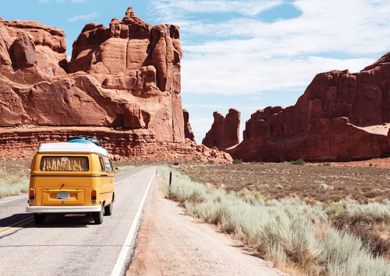
Input: A photo taken from a paved road cutting through a red rock canyon, with a vintage yellow and white camper van driving away from the camera. Tall, weathered sandstone towers rise on both sides of the road under a partly cloudy sky, with scrubby desert brush lining the shoulder.
- Arches National Park, Utah55%
- Capitol Reef National Park, Utah25%
- Monument Valley, Arizona/Utah20%
Most likely identification: This scene matches the entrance road through Arches National Park in Utah, where a paved route runs between towering red sandstone formations similar to the Courthouse Towers area, though no signage is visible to confirm the exact spot.
Why the confidence isn't higher: Several southwestern US parks share this look: tall red rock towers, a two-lane road, and desert scrub. Without a named formation or visitor center sign in frame, the model is estimating from color, rock shape, and road style rather than a confirmed marker.
Background: Arches National Park sits near Moab, Utah, and is known for over 2,000 natural sandstone arches formed by erosion over millions of years, along with balanced rocks and freestanding towers like the ones shown here.
Travel note: Roads like this one are busiest at sunrise and sunset when the rock glows red, and pulling fully off the pavement to photograph is safer than stopping on the road itself.
How it works
- 1
Upload a clear photo of the landmark
A photo that shows the structure's shape, materials, and surroundings works better than a distant or heavily cropped shot.
- 2
Add context if you have it
Mention the country, city, or trip the photo is from, and the answer narrows toward landmarks that fit that context.
- 3
The model compares visible features
It looks at the shape, materials, scale, and surrounding landscape or architecture to estimate which landmark the photo most likely shows.
- 4
You get a name, history, and confidence scores
The result names the most likely landmark with historical context and travel notes, and lists other candidates as percentages when the photo resembles more than one site.
Use cases
Sorting through old travel photos
Someone digging through a phone's camera roll years later uploads an unlabeled photo to figure out which trip or country it's actually from.
Identifying a landmark from someone else's photo
A person sees an interesting building or monument on social media without a caption and wants to know what it is and where to find it.
Planning a trip around similar landmarks
Someone who liked a landmark in a photo uses the result's background section to look for other, similar sites worth visiting nearby.
Settling a disagreement about a photo's location
Two people disagree about where a vacation photo was taken, and the tool's candidate list with scores gives a starting point to check against.
Tips for better results
- Include some of the surrounding landscape or street in the frame, not just a tight crop of the structure itself.
- Mention the country or region if you remember it, since that context narrows the guess considerably.
- Use a daytime photo when possible; heavy shadows or night lighting can obscure identifying details.
- If a nearby sign, plaque, or ticket is visible, mention what it says in the notes for a more confident answer.
- For landmarks with several similar sites nearby, note any details like the name of the trail or neighborhood if you know them.
Frequently asked questions
What if the landmark isn't famous enough to recognize?
It works best on landmarks with a strong online presence. Lesser-known local sites may come back as a lower-confidence guess or an unclear result.
Why does it sometimes list more than one landmark?
Many landmarks share visual traits, like red rock canyons or European plazas, so the tool lists each plausible match with a percentage instead of forcing one answer.
Can it identify a landmark from a partial or distant photo?
It can try, but a distant or heavily cropped photo gives the model less to work with, which usually lowers confidence in the top guess.
Does it know the exact GPS coordinates of the landmark?
No, it estimates identity from visual features, not location data, so it names the landmark and general area rather than exact coordinates.
Can I ask about the landmark's history in more detail?
Add a specific question in the details box, like asking about the construction date, and the answer will address it alongside the identification.
Will it recognize landmarks that have changed over time?
It can struggle with landmarks that have been renovated, damaged, or rebuilt since older reference photos were taken, which can lower confidence.
Plans start at $9 a month. See pricing